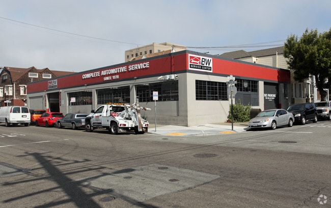
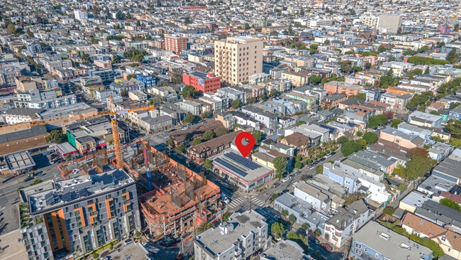
Property Record
3260 26Th St, San Francisco, CA 94110

NEARBY LISTINGS FOR SALE OR LEASE
Property Detail
3260 26Th St
San Francisco-Redwood City-South San Francisco, CA
Mission Bl 181
6526-012
San Francisco
Industrialgeneral
California
2024
12
2025
0.17 AC
022901
Mission/Potrero
7,460 SF
San Francisco
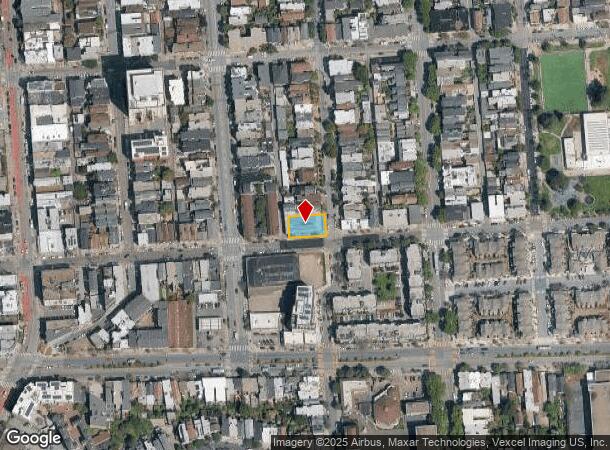
DEMOGRAPHICS near 3260 26Th St
1 Mile
3 Mile
5 Mile
2024 Total Population
73,056
498,469
821,614
2029 Population
68,092
461,063
760,048
Pop Growth 2024-2029
(6.79%)
(7.50%)
(7.49%)
Average Age
41
42
42
2024 Total Households
29,913
212,323
343,851
HH Growth 2024-2029
(7.38%)
(7.83%)
(7.83%)
Median Household Inc
$157,757
$124,147
$125,241
Avg Household Size
2.30
2.20
2.20
2024 Avg HH Vehicles
1.00
1.00
1.00
Median Home Value
$1,114,682
$1,087,721
$1,093,272
Median Year Built
1947
1952
1949
Nearby Places
Map Layers
Map Styles
 Street
 Aerial
- Restaurants
- Banks
- Shops
- Fitness
- Groceries
PUBLIC TRANSPORTATION
TRANSIT/SUBWAY
24th St Mission Station (Dublin/Pleasanton - Millbrae - Bay Area Rapid Transit (BART), Fremont - Daly City - Bay Area Rapid Transit (BART), Pittsburg/Bay Point - San Francisco International - Bay Area Rapid Transit (BART), Richmond - Millbrae - Bay Area Rapid Transit (BART))
DRIVE
WALK
Distance
24th St Mission Station (Dublin/Pleasanton - Millbrae - Bay Area Rapid Transit (BART), Fremont - Daly City - Bay Area Rapid Transit (BART), Pittsburg/Bay Point - San Francisco International - Bay Area Rapid Transit (BART), Richmond - Millbrae - Bay Area Rapid Transit (BART))
2 min
7 min
0.3 mi
Church and Clipper (J Church - San Francisco Municipal Railway (MUNI Metro))
DRIVE
WALK
Distance
Church and Clipper (J Church - San Francisco Municipal Railway (MUNI Metro))
3 min
14 min
0.7 mi
30th Street and Dolores (J Church - San Francisco Municipal Railway (MUNI Metro))
DRIVE
WALK
Distance
30th Street and Dolores (J Church - San Francisco Municipal Railway (MUNI Metro))
4 min
15 min
0.8 mi
Church and 24th Street (J Church - San Francisco Municipal Railway (MUNI Metro))
DRIVE
WALK
Distance
Church and 24th Street (J Church - San Francisco Municipal Railway (MUNI Metro))
3 min
16 min
0.8 mi
Church and 29th Street (J Church - San Francisco Municipal Railway (MUNI Metro))
DRIVE
WALK
Distance
Church and 29th Street (J Church - San Francisco Municipal Railway (MUNI Metro))
4 min
17 min
0.9 mi
COMMUTER RAIL
DRIVE
WALK
Distance
7 min
2.8 mi
22nd Street (Caltrain - Caltrain (Caltrain))
DRIVE
WALK
Distance
22nd Street (Caltrain - Caltrain (Caltrain))
7 min
2.9 mi
AIRPORT
San Francisco International
DRIVE
WALK
Distance
San Francisco International
19 min
11.4 mi
Metro Oakland International
DRIVE
WALK
Distance
Metro Oakland International
35 min
22.2 mi
Norman Y Mineta San Jose International
DRIVE
WALK
Distance
Norman Y Mineta San Jose International
54 min
43.1 mi
Freight Ports
Port of San Francisco
DRIVE
WALK
Distance
Port of San Francisco
12 min
5.1 mi
SALE & LEASE HISTORY
LISTING DATE
SALE/LEASE

Nov 24, 2025
For Sale
Nearby Properties
Address
Land Use
TOTAL SIZE
Lot Size
Zoning
Address
Land Use
TOTAL SIZE
Lot Size
Zoning
1,015,000 SF
2.43 AC
RC4
Address
Land Use
TOTAL SIZE
Lot Size
Zoning
750,370 SF
3.25 AC
MBR3
Address
Land Use
TOTAL SIZE
Lot Size
Zoning
1,420,430 SF
1.16 AC
C3OSD
Address
Land Use
TOTAL SIZE
Lot Size
Zoning
248,303 SF
4.35 AC
Address
Land Use
TOTAL SIZE
Lot Size
Zoning
717,234 SF
3.47 AC
UMU
Address
Land Use
TOTAL SIZE
Lot Size
Zoning
475,791 SF
0.55 AC
C3OSD
Address
Land Use
TOTAL SIZE
Lot Size
Zoning
690,442 SF
0.79 AC
C3O
Address
Land Use
TOTAL SIZE
Lot Size
Zoning
10.92 AC
Address
Land Use
TOTAL SIZE
Lot Size
Zoning
750,491 SF
0.51 AC
C3O
Address
Land Use
TOTAL SIZE
Lot Size
Zoning
432,000 SF
0.35 AC
C3OSD
Address
Land Use
TOTAL SIZE
Lot Size
Zoning
266,143 SF
4 AC
C-3-R
Address
Land Use
TOTAL SIZE
Lot Size
Zoning
885,581 SF
5.20 AC
M2
Address
Land Use
TOTAL SIZE
Lot Size
Zoning
508,714 SF
1.29 AC
C3R
Address
Land Use
TOTAL SIZE
Lot Size
Zoning
505,120 SF
0.41 AC
C3O
Address
Land Use
TOTAL SIZE
Lot Size
Zoning
696,431 SF
0.97 AC
C3G
Address
Land Use
TOTAL SIZE
Lot Size
Zoning
139,070 SF
0.64 AC
C3O
Address
Land Use
TOTAL SIZE
Lot Size
Zoning
1.52 AC
C3G
Address
Land Use
TOTAL SIZE
Lot Size
Zoning
1,424,230 SF
2.60 AC
C3G
Address
Land Use
TOTAL SIZE
Lot Size
Zoning
614,740 SF
1.74 AC
C3OSD
Address
Land Use
TOTAL SIZE
Lot Size
Zoning
385,000 SF
0.81 AC
C3O
Address
Land Use
TOTAL SIZE
Lot Size
Zoning
370,694 SF
0.87 AC
RH DTR
Address
Land Use
TOTAL SIZE
Lot Size
Zoning
263,640 SF
0.72 AC
C3R
Address
Land Use
TOTAL SIZE
Lot Size
Zoning
519,235 SF
0.74 AC
C3O
Address
Land Use
TOTAL SIZE
Lot Size
Zoning
2.74 AC
Address
Land Use
TOTAL SIZE
Lot Size
Zoning
313,306 SF
1.23 AC
WMUG
Address
Land Use
TOTAL SIZE
Lot Size
Zoning
307,000 SF
0.87 AC
C3OSD
Address
Land Use
TOTAL SIZE
Lot Size
Zoning
314,826 SF
1.85 AC
MB-RA
Address
Land Use
TOTAL SIZE
Lot Size
Zoning
922,758 SF
1.94 AC
C3R
Address
Land Use
TOTAL SIZE
Lot Size
Zoning
385,558 SF
1.24 AC
C3OSD
Address
Land Use
TOTAL SIZE
Lot Size
Zoning
10.92 AC
The World's #1 Commercial Real Estate Marketplace
Connect with us
© 2025 CoStar Group
The information above has been obtained from sources believed reliable. While we do not doubt its accuracy we have not verified it and make no guarantee, warranty or representation about it. It is your responsibility to independently confirm its accuracy and completeness. Any projections, opinions, assumptions, or estimates used are for example only and do not represent the current or future performance of the property. The value of this transaction to you depends on tax and other factors which should be evaluated by your tax, financial, and legal advisors. You and your advisors should conduct a careful, independent investigation of the property to determine to your satisfaction the suitability of the property for your needs.